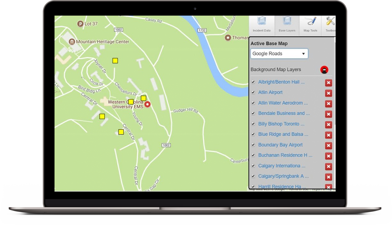
Menu

Building a Common Operating Picture with GIS Mapping

The Right Geographic Information Systems (GIS) Mapping Technology

Building a shared common operating picture (COP) with multiple users is a difficult and time-consuming process. With COBRA GIS Mapping, you no longer need to worry about finding the right GIS mapping technology to add the right information. COBRA GIS Mapping gives users an easy and powerful tool for creating custom COP maps viewable by all users.

COBRA GIS Mapping allows for displaying different types of information such as residential and commercial facilities, decon zones, shelters, building damage, severe weather, designated areas of activity, personnel “status”, and real time resource locations. COBRA GIS Mapping allows users to see information in real-time and make changes to that information as needed. Users can add icons, sketches, points, lines, concentric circles, measurements, and polygons.

cobra gis mapping capabilities outlined on a computer screen

Base Layers

The COBRA GIS Mapping Interface is a core component of our system, enabling the visualization of any data point that is associated with location information (latitude/longitude, MGRS coordinates, physical address, etc.). This information can be layered over a set of default base mapping resources, including Google™ (satellite, roads, or hybrid views), Open Street Maps, and ThinkGeo.

woman looking at gis mapping system

Information Sharing

COBRA GIS Mapping can easily be exported into other tools such as Google Earth and Google Maps. COBRA Mapping automatically geo-tag all incident data in real time, integrate with other mapping and GIS applications, and export data to Google Earth for information sharing with other agencies.

gis mapping on a tablet

Mapping Tools for Visual Overviews

COBRA GIS Mapping allows users and managers to quickly see and understand information in the system, anywhere, anytime.

cobra gis mapping Features
  • Real time collaborative mapping and sketching capability
  • Incident based – shows locations of incidents, hazards, threats, forces
  • Compatible with ESRI and Google Maps
  • Users can view their distance from incident for faster analysis of travel resources needs
  • Automatic geolocation analysis features can identify organizations that have shared response coverage
  • Use with Google roads, Google Earth, Google Hybrid, ThinkGeo, Open street view, Military Grid Reference System or users’ own base map layer
  • Administrators control access to information (View Only to Full Add/Edit Rights) allowing for greater control of data sharing
command center using gis mapping technology

Background Map Layer Support

The COBRA Background Map Layer Support tool gives customers the freedom to use GIS built maps inside COBRA.

cobra gis mapping Features
  • COBRA supports GIS datasets including shapefiles (SHP), Keyhole Markup Language (KML), and GeoJson map files
  • Data layers are customized with custom coloring, thickness, opacity, icons, map categorizing, and data types
gis mapping used for shelters

COBRA Critical Infrastructure and Facilities

The COBRA Critical Infrastructure and Facilities tool provides users the ability to add and store critical planning and response information for facility information. Each facility record allows for locating the facility on a map, showing facility contact details, and adding attachments related to the facility such as floor plans and Safety Data Sheets for facilities that store hazmat.

Facility and critical infrastructure locations are displayable on a map allowing quick and easy determination of whether vulnerable facilities are close to an incident.

Evacuation Shelters

Within COBRA, facilities classified as evacuation shelters allow input of information relevant for shelter managers, such as name of the facility, building manager, shelter manager, day and night shelter capacity for general, toddler, school age, elderly, handicapped, and pet population.

The shelter information card outlines general, day, and night capacities for general, toddler, preschool, elderly, and handicapped populations. Facility parking and transport accessibility information for vehicles, public transportation, and helicopter access is available. Shelter information includes complete POC information, activation procedures, and supplementary information during activation.


Tier II/Chemical Facility

Tier II/Chemical Facility Information includes the types of chemicals located in the facility, quantity stored, chemical type, processing activities, accident scenarios, occupancy on site, impact on personnel and the environment, onsite emergency response capabilities (including fire, hazmat, rescue, medical, transportation), and extensive contact information for emergency.

The Tier II/Chemical Facility card allows organization administrators to add information about the Tier II/Chemical facilities available in their community. Information includes the types of chemical located in the facility, who to contact in an emergency, and other critical information for managing facilities with Tier 2 chemicals.

The Tier II/Chemical Facility card also provides information for the type of chemicals stored, quantity stored, chemical type, processing activities, accident scenarios, occupancy on site, impact on personnel and the environment, onsite emergency response capabilities (including fire, hazmat, rescue, medical, transportation) and extensive contact information for emergency POCs, corporate contact, security, medical, fire, PIO, public safety liaison, etc.


Hospital Bed Capacity

The Hospital Bed capacity tool also provides a quick search tool for responders to search for a specific number of bed types within the incident location, allowing them to rapidly find enough beds that can handle the correct injury type closest to the incident’s location.

Hospital POC information for bed reservation, numbers for Mass Casualty Incident casualty reception including capacity for Adult ICU, Pediatric ICU, Neonatal ICU, General Surgery, Emergency Department, Standard Isolation, Negative Flow Isolation, Operating Rooms, and Burn Beds are also available.

The hospital bed capacity tool allows hospital administrators to update their hospital bed status on a 24-hour cycle. Additional facility information includes layout of the facility, lockdown procedures, parking and helicopter access.


an example of gis mapping on a laptop screen

Mapping Threats Fast and Effectively

Quickly assessing where a chemical plume will go or is currently located is key when determining who to evacuate, when, and where. Using the COBRA Plume Manager, incident commanders and hazmat personnel can quickly and easily determine evacuation zones and routes based on chemical type, explosive device, and nuclear yields.

The COBRA Plume Manager Features
  • Uses Aloha, HPAC/JEM, SAFER, ERG, Explosive Standoff zones, and Nuclear Device Effects models to effectively generate plumes
  • Is based on type of chemical spilled, spill size, time of day, and wind direction
  • Overlays plumes on a map allowing first responders to quickly assess and act
gis mapping used to track a fire

COBRA Explosive Evacuation Zones

Using the COBRA Explosive Evacuation tool, incident commanders who find a explosive device can quickly and easily determine how far is safe enough.

The COBRA Explosive Evacuation tool tracks
  • High explosive or propane gas
  • Explosive or vehicle size and type
  • 100% evacuation zones
  • Shelter in place zones
gis mapping used to communicate during a natural disaster

COBRA Nuclear Device Effects

While nuclear events are rare, it is still important for emergency planners to forecast nuclear attacks. Using the COBRA Nuclear Device Effects tool, planners have an effective way to generate nuclear blast information and forecast the nuclear effects on a community.

Even though many factors, such as burst conditions, weather, terrain, and weapon design, introduce uncertainties in assessing weapons effects, the data presented by the tool offers the best available approximations for purposes of orientation and protective planning.

Your community and your organization depend on you. Let’s get it right, together.

Schedule Your Demo